
Bad Brückenau topographic map
Interactive map
Click on the map to display elevation.
About this map
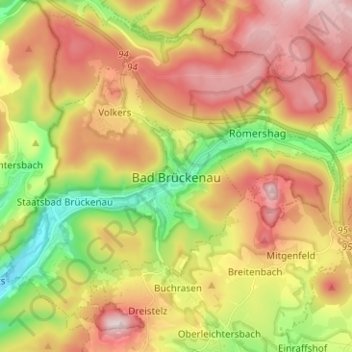
Name: Bad Brückenau topographic map, elevation, terrain.
Location: Bad Brückenau, Landkreis Bad Kissingen, Bavaria, 97769, Germany (50.27853 9.72750 50.34228 9.85291)
Average elevation: 464 m
Minimum elevation: 270 m
Maximum elevation: 653 m
Other topographic maps
Click on a map to view its topography, its elevation and its terrain.
Bad Kissingen
Germany > Bavaria > Landkreis Bad Kissingen > Bad Kissingen > Bad Kissingen
Average elevation: 295 m
Hammelburg
Germany > Bavaria > Landkreis Bad Kissingen > Hammelburg > Hammelburg
Average elevation: 260 m