
Sarona topographic map
Interactive map
Click on the map to display elevation.
About this map
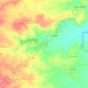
Name: Sarona topographic map, elevation, terrain.
Location: Sarona, Kushalgarh Tehsil, Banswara District, Rajasthan, India (23.20060 74.65450 23.24060 74.69450)
Average elevation: 406 m
Minimum elevation: 369 m
Maximum elevation: 436 m
Other topographic maps
Click on a map to view its topography, its elevation and its terrain.
Serona
India > Rajasthan > Kushalgarh Tehsil > Sarona
Serona, Sarona, Kushalgarh Tehsil, Banswara District, Rajasthan, India
Average elevation: 402 m