
Taza National Park topographic map
Interactive map
Click on the map to display elevation.
Taza National Park
At lower altitudes, the Guerrouch forest is largely dominated by cork oaks, but higher up Algerian chestnut-leaved oak (Quercus afares) and Algerian oak (Quercus canariensis) are also present and there is a plentiful understorey of bird cherry (Prunus avium), Mediterranean willow (Salix pedicellata), European alder (Alnus glutinosa), Montpellier maple (Acer monspessulanum) and narrow-leaved ash (Fraxinus angustifolia).
About this map
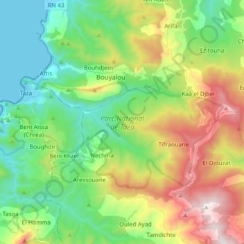
Name: Taza National Park topographic map, elevation, terrain.
Average elevation: 437 m
Minimum elevation: 0 m
Maximum elevation: 1,275 m