
Gadahinglaj topographic map
Interactive map
Click on the map to display elevation.
About this map
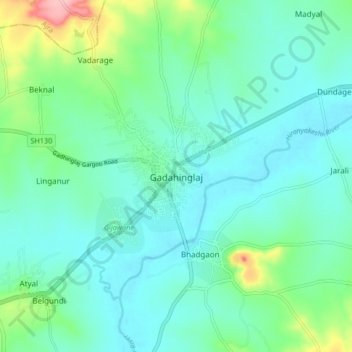
Name: Gadahinglaj topographic map, elevation, terrain.
Location: Gadahinglaj, Gadhinglaj, Kolhapur, Maharashtra, 416502, India (16.18369 74.31159 16.26369 74.39159)
Average elevation: 655 m
Minimum elevation: 624 m
Maximum elevation: 773 m
Gadhinglaj is situated on the banks of the Hiranyakeshi river, which originates in the Amboli Ghats mountains. It is located at the border between Maharashtra and Karnataka. Maharashtra State Highway 134 passes through the city. Gadinglaj is the headquarters of South Kolhapur and a sub-district of the Kolhapur District. It is the largest city in South Kolhapur and has enough area and population to be deemed a district. The city is at an average elevation of 623 metres (2,044 ft).
Other topographic maps
Click on a map to view its topography, its elevation and its terrain.
Hasurwadi
India > Maharashtra > Gadhinglaj
Hasurwadi, Gadhinglaj, Kolhapur, Maharashtra, India
Average elevation: 783 m
Ainapur
India > Maharashtra > Gadhinglaj
Ainapur, Gadhinglaj, Kolhapur, Maharashtra, India
Average elevation: 652 m
Samangad Fort
India > Maharashtra > Gadhinglaj > Chinchewadi
Samangad Fort, Chinchewadi, Gadhinglaj, Kolhapur, Maharashtra, India
Average elevation: 798 m
Nesari
India > Maharashtra > Gadhinglaj
Nesari, Gadhinglaj, Kolhapur, Maharashtra, 416504, India
Average elevation: 730 m
Mahagaon
India > Maharashtra > Gadhinglaj > Mahagaon
Mahagaon, Gadhinglaj, Kolhapur district, Maharashtra, India
Average elevation: 656 m