
Make a donation
Gear up for your next adventure:
As an Amazon Associate, this site earns from qualifying purchases at no extra cost to you.
Cline River topographic map
Click on the map to display elevation.
Make a donation
Gear up for your next adventure:
As an Amazon Associate, this site earns from qualifying purchases at no extra cost to you.
About this map
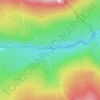
Name: Cline River topographic map, elevation, terrain.
Location: Cline River, Clearwater County, Alberta, Canada (52.15153 -116.54827 52.15195 -116.54772)
Average elevation: 1,545 m
Minimum elevation: 1,399 m
Maximum elevation: 1,745 m
Make a donation
Gear up for your next adventure:
As an Amazon Associate, this site earns from qualifying purchases at no extra cost to you.
Other topographic maps
Click on a map to view its topography, its elevation and its terrain.
Nordegg
Canada > Alberta > Clearwater County
Nordegg has a subarctic climate (Dfc) which can be considered a subalpine climate due to its altitude with locations on the same latitude having warmer climates. Summers are mild, with a few warm days sprinkled in here and there, while winters are cold and snowy.
Average elevation: 1,475 m
Make a donation
Gear up for your next adventure:
As an Amazon Associate, this site earns from qualifying purchases at no extra cost to you.
Make a donation
Gear up for your next adventure:
As an Amazon Associate, this site earns from qualifying purchases at no extra cost to you.
Nordegg
Canada > Alberta > Clearwater County
Nordegg has a subarctic climate (Dfc) which can be considered a subalpine climate due to its altitude with locations on the same latitude having warmer climates. Summers are mild, with a few warm days sprinkled in here and there, while winters are cold and snowy.
Average elevation: 1,475 m
Nordegg
Canada > Alberta > Clearwater County
Nordegg has a subarctic climate (Dfc) which can be considered a subalpine climate due to its altitude with locations on the same latitude having warmer climates. Summers are mild, with a few warm days sprinkled in here and there, while winters are cold and snowy.
Average elevation: 1,399 m
Make a donation
Gear up for your next adventure:
As an Amazon Associate, this site earns from qualifying purchases at no extra cost to you.
Make a donation
Gear up for your next adventure:
As an Amazon Associate, this site earns from qualifying purchases at no extra cost to you.