
Kutum topographic map
Interactive map
Click on the map to display elevation.
About this map
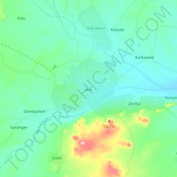
Name: Kutum topographic map, elevation, terrain.
Location: Kutum, North Darfur State, Sudan (14.17084 24.60958 14.25084 24.68958)
Average elevation: 1,145 m
Minimum elevation: 1,105 m
Maximum elevation: 1,275 m
Other topographic maps
Click on a map to view its topography, its elevation and its terrain.
Gumut
Sudan > North Darfur State > Kutum > Gumut
Gumut, Kutum, North Darfur State, Sudan
Average elevation: 1,203 m