Geolocate

Edoor topographic map

Click on the map to display elevation.

About this map

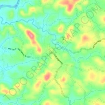
Name: Edoor topographic map, elevation, terrain.

Location: Edoor, Iritty, Kannur, Kerala, 670704, India (11.97724 75.70633 12.01724 75.74633)

Average elevation: 64 m

Minimum elevation: 25 m

Maximum elevation: 125 m

Other topographic maps

Click on a map to view its topography, its elevation and its terrain.

Ulikkal

India > Kerala > Iritty > Nuchiyad

Average elevation: 161 m

Iritty

India > Kerala > Iritty

Average elevation: 65 m

Kottiyoor

India > Kerala > Iritty > Ambayathode

Average elevation: 394 m

Aralam

India > Kerala > Iritty > Iritty

Average elevation: 86 m

Kelakam

India > Kerala > Iritty > Adakkathodu

Average elevation: 324 m

Aralam WLS

India > Kerala > Iritty > Adakkathodu

Average elevation: 462 m

Gear up for your next adventure:

Lightweight Tents - Compact tents for backpacking and trekking
🚲Bikepacking Frame Bags - Storage for tools and navigation gear on long off-road rides
🥼Base Layers - Thermal base layers for temperature regulation
🧥Softshell Jackets - Breathable jackets for active outdoor use
🔋Rechargeable Batteries - Eco-friendly power for headlamps and older GPS units

As an Amazon Associate, this site earns from qualifying purchases at no extra cost to you.