
Aquamarina topographic map
Interactive map
Click on the map to display elevation.
About this map
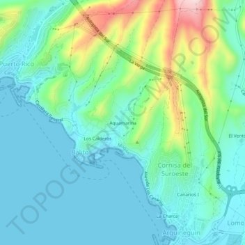
Name: Aquamarina topographic map, elevation, terrain.
Location: Aquamarina, Mogán, Las Palmas, Canary Islands, 35129, Spain (27.75697 -15.71215 27.79697 -15.67215)
Average elevation: 75 m
Minimum elevation: 0 m
Maximum elevation: 315 m
Other topographic maps
Click on a map to view its topography, its elevation and its terrain.
Playa de Mogán
Playa de Mogán, Mogán, Las Palmas, Canary Islands, 35138, Spain
Average elevation: 94 m