
Panpoli topographic map
Interactive map
Click on the map to display elevation.
About this map
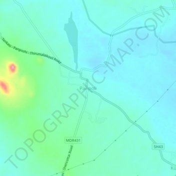
Name: Panpoli topographic map, elevation, terrain.
Location: Panpoli, Shenkottai, Tenkasi District, Tamil Nadu, 627807, India (9.00018 77.23295 9.04018 77.27295)
Average elevation: 198 m
Minimum elevation: 177 m
Maximum elevation: 297 m
Other topographic maps
Click on a map to view its topography, its elevation and its terrain.
Kulathoor
India > Tamil Nadu > Shenkottai
Kulathoor, Shenkottai, Tenkasi District, Tamil Nadu, 627807, India
Average elevation: 186 m
Shencottai
India > Tamil Nadu > Shenkottai > Shencottai
Shencottai, Shenkottai, Tenkasi District, Tamil Nadu, 627809, India
Average elevation: 188 m