
Geiselwind topographic map
Interactive map
Click on the map to display elevation.
About this map
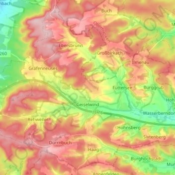
Name: Geiselwind topographic map, elevation, terrain.
Location: Geiselwind, Landkreis Kitzingen, Beieren, Duitsland (49.74054 10.41976 49.82326 10.55526)
Average elevation: 396 m
Minimum elevation: 290 m
Maximum elevation: 482 m
Other topographic maps
Click on a map to view its topography, its elevation and its terrain.
Schwarzach am Main
Duitsland > Beieren > Landkreis Kitzingen
Schwarzach am Main, Landkreis Kitzingen, Beieren, 97359, Duitsland
Average elevation: 210 m
Neuenberg
Duitsland > Beieren > Landkreis Kitzingen > Iphofen
Neuenberg, Iphofen, Iphofen (VGem), Landkreis Kitzingen, Beieren, Duitsland
Average elevation: 315 m
Volkach
Duitsland > Beieren > Landkreis Kitzingen > Volkach
Volkach, Volkach (VGem), Landkreis Kitzingen, Beieren, 97332, Duitsland
Average elevation: 238 m