
Ventoquipa topographic map
Interactive map
Click on the map to display elevation.
About this map
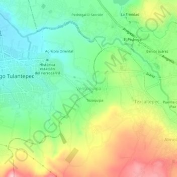
Name: Ventoquipa topographic map, elevation, terrain.
Average elevation: 2,238 m
Minimum elevation: 2,167 m
Maximum elevation: 2,346 m
Other topographic maps
Click on a map to view its topography, its elevation and its terrain.
Santiago Tulantepec
México > Hidalgo > Santiago Tulantepec de Lugo Guerrero
Santiago Tulantepec, Santiago Tulantepec de Lugo Guerrero, Hidalgo, 43690, México
Average elevation: 2,260 m