Geolocate

Royal topographic map

Click on the map to display elevation.

About this map

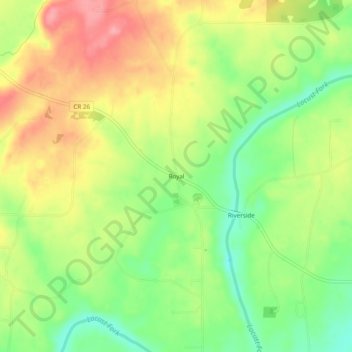
Name: Royal topographic map, elevation, terrain.

Location: Royal, Blount County, Alabama, United States (34.05204 -86.52221 34.09204 -86.48221)

Average elevation: 234 m

Minimum elevation: 183 m

Maximum elevation: 288 m

Other topographic maps

Click on a map to view its topography, its elevation and its terrain.

Oneonta

United States > Alabama > Blount County

Average elevation: 278 m

Rosa

United States > Alabama > Blount County

Average elevation: 234 m

Hayden

United States > Alabama > Blount County

Average elevation: 180 m

Hayden

United States > Alabama > Blount County

Average elevation: 180 m

Hayden

United States > Alabama > Blount County

Average elevation: 180 m

Blountsville

United States > Alabama > Blount County

Average elevation: 247 m

Snead

United States > Alabama > Blount County

Average elevation: 238 m

Oneonta

United States > Alabama > Blount County

Average elevation: 277 m

Locust Fork

United States > Alabama > Blount County

Average elevation: 186 m

Gear up for your next adventure:

🧥Packable Down Jackets - Lightweight warmth that compresses small in your bag
🛌Sleeping Mats - Insulated mats for comfortable outdoor sleeping
🚶Walking Pedometers - Simple distance tracking for casual trail walkers
🎒Hiking Backpacks - Comfortable backpacks for day hikes and multi-day treks
🐕Hiking Dog Harnesses - Rugged harnesses for taking your companion on mountain trails

As an Amazon Associate, this site earns from qualifying purchases at no extra cost to you.