
Trappstadt topographic map
Interactive map
Click on the map to display elevation.
About this map
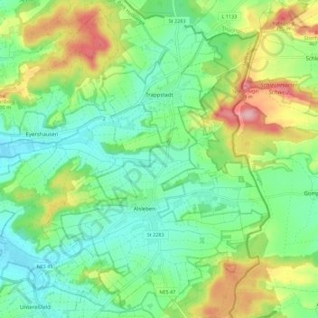
Name: Trappstadt topographic map, elevation, terrain.
Average elevation: 333 m
Minimum elevation: 281 m
Maximum elevation: 438 m
Other topographic maps
Click on a map to view its topography, its elevation and its terrain.
Grabfeld
Deutschland > Bayern > Landkreis Rhön-Grabfeld > Trappstadt
Grabfeld, Grüner Hain, Trappstadt, Bad Königshofen i. Grabfeld (VGem), Landkreis Rhön-Grabfeld, Bayern, 97633, Deutschland
Average elevation: 342 m