Geolocate

Chemanchery topographic map

Click on the map to display elevation.

About this map
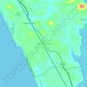
Name: Chemanchery topographic map, elevation, terrain.

Location: Chemanchery, Koyilandi, Kozhikode, Kerala, 673304, India (11.37503 75.70635 11.41503 75.74635)

Average elevation: 11 m

Minimum elevation: -1 m

Maximum elevation: 54 m

Other topographic maps

Click on a map to view its topography, its elevation and its terrain.
Kayanna

India > Kerala > Koyilandi > Kayanna Bazar

Average elevation: 67 m

vayalada

India > Kerala > Koyilandi > Vattachira

Average elevation: 214 m

Moodadi

India > Kerala > Koyilandi > Thikkodi

Average elevation: 10 m

Balussery

India > Kerala > Koyilandi > Balusseri

Average elevation: 39 m

Kariyathumpara

India > Kerala > Koyilandi > Vallayil Thazhe

Average elevation: 543 m

Malabar WLS

India > Kerala > Koyilandi > Vythiri

Average elevation: 932 m

Kuttiyadi river

India > Kerala > Koyilandi > Peruvannamuzhi

Average elevation: 112 m

Balussery

India > Kerala > Koyilandi > Panayi

Average elevation: 39 m

Unnikulam

India > Kerala > Koyilandi > Karumala

Average elevation: 52 m

Gear up for your next adventure:

📦Dry Bags - Waterproof bags to protect gear from rain
🧰Survival Kits - Emergency tools for remote environments
☕Insulated Travel Mugs - Keep drinks hot while surveying the landscape from a summit
🕶️Polarized Sunglasses - Reduces glare from snow and water when reading terrain
🔥Reusable Hand Warmers - Maintain dexterity in your fingers for precise map handling

As an Amazon Associate, this site earns from qualifying purchases at no extra cost to you.