
Winter Hill topographic map
Interactive map
Click on the map to display elevation.
Winter Hill
Paths to the summit lead from Belmont (in Blackburn with Darwen), Rivington (in Chorley), and Horwich and Blackrod (in Bolton). The summit can also be reached via a short walk from the top of a road pass 1+1⁄4 miles (2 km) west of Belmont. The hill is a prominent natural landmark on the skyline for the most of Chorley and further afield. Winter Hill's topographic prominence results in it being classified as a Marilyn. The trig point on its summit marks the highest point in Blackburn with Darwen whereas the highest point in Bolton is 440 yards (400 m) away on its south east slope at 1,467 feet (447 m) above sea level.
About this map
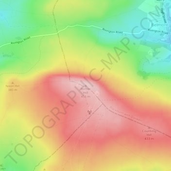
Name: Winter Hill topographic map, elevation, terrain.
Average elevation: 357 m
Minimum elevation: 236 m
Maximum elevation: 456 m
Routes: Blackburn with Darwen GPS tracks, routes, trails, hikes
Other topographic maps
Click on a map to view its topography, its elevation and its terrain.
Electricty Northwest
United Kingdom > England > Blackburn with Darwen > Belmont
Average elevation: 356 m