
Dayton topographic map
Interactive map
Click on the map to display elevation.
About this map
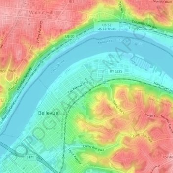
Name: Dayton topographic map, elevation, terrain.
Location: Dayton, Campbell County, Kentucky, 41074, United States (39.10194 -84.48519 39.12194 -84.44079)
Average elevation: 190 m
Minimum elevation: 139 m
Maximum elevation: 259 m
Other topographic maps
Click on a map to view its topography, its elevation and its terrain.
Newport
United States > Kentucky > Campbell County
Newport, Campbell County, Kentucky, 41071, United States
Average elevation: 173 m
Melbourne
United States > Kentucky > Campbell County
Melbourne, Campbell County, Kentucky, United States
Average elevation: 168 m
Alexandria
United States > Kentucky > Campbell County
Alexandria, Campbell County, Kentucky, United States
Average elevation: 220 m
Fort Thomas
United States > Kentucky > Campbell County
Fort Thomas, Campbell County, Kentucky, 41075, United States
Average elevation: 192 m
Newport
United States > Kentucky > Campbell County > Newport
Newport, Campbell County, Kentucky, 41071-9998, United States
Average elevation: 195 m
Cold Spring
United States > Kentucky > Campbell County
Cold Spring, Campbell County, Kentucky, 41076, United States
Average elevation: 211 m
Wilder
United States > Kentucky > Campbell County
Wilder, Campbell County, Kentucky, United States
Average elevation: 207 m
Highland Heights
United States > Kentucky > Campbell County
Highland Heights, Campbell County, Kentucky, 41099, United States
Average elevation: 237 m