Quan Hóa District topographic map
Interactive map
Click on the map to display elevation.
About this map
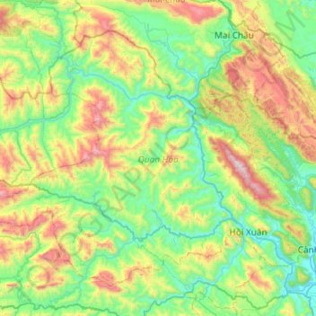
Name: Quan Hóa District topographic map, elevation, terrain.
Location: Quan Hóa District, Thanh Hoá Province, Vietnam (20.30259 104.70150 20.67067 105.18757)
Average elevation: 489 m
Minimum elevation: 41 m
Maximum elevation: 1,630 m
Other topographic maps
Click on a map to view its topography, its elevation and its terrain.
Ngọc Lặc District
Ngọc Lặc District, Thanh Hoá Province, Vietnam
Average elevation: 104 m
Triệu Sơn District
Triệu Sơn District, Thanh Hoá Province, Vietnam
Average elevation: 35 m
Hoằng Hóa District
Hoằng Hóa District, Thanh Hoá Province, 43000, Vietnam
Average elevation: 8 m
Thạch Thành District
Thạch Thành District, Thanh Hoá Province, Vietnam
Average elevation: 92 m
Ben Sung
Ben Sung, Như Thanh District, Thanh Hoa province, Vietnam
Average elevation: 36 m
Thanh Hoá
Thanh Hoá, Thanh Hoá Province, 45000, Vietnam
Average elevation: 6 m
Bưởi River
Vietnam > Thanh Hoa province > Vĩnh Lộc District > Vĩnh Lộc
Bưởi River, Vĩnh Lộc, Vĩnh Lộc District, Thanh Hoa province, Vietnam
Average elevation: 29 m
Thôn Bảy
Vietnam > Thanh Hoa province > Nghi Sơn > Thôn Bảy
Thôn Bảy, Nghi Sơn, Thanh Hoa province, Vietnam
Average elevation: 34 m