
Thank you for supporting this site ❤️
Make a donation
Make a donation
Gear up for your next adventure:
As an Amazon Associate, this site earns from qualifying purchases at no extra cost to you.
Pakuhaji topographic map
Click on the map to display elevation.
Thank you for supporting this site ❤️
Make a donation
Make a donation
Gear up for your next adventure:
As an Amazon Associate, this site earns from qualifying purchases at no extra cost to you.
About this map
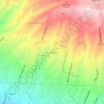
Name: Pakuhaji topographic map, elevation, terrain.
Location: Pakuhaji, Cimahi, West Java, Java, 40511, Indonesia (-6.85096 107.52507 -6.81096 107.56507)
Average elevation: 1,016 m
Minimum elevation: 773 m
Maximum elevation: 1,265 m
Thank you for supporting this site ❤️
Make a donation
Make a donation
Gear up for your next adventure:
As an Amazon Associate, this site earns from qualifying purchases at no extra cost to you.