
Make a donation
Gear up for your next adventure:
As an Amazon Associate, this site earns from qualifying purchases at no extra cost to you.
Tinian Municipality topographic map
Click on the map to display elevation.
Make a donation
Gear up for your next adventure:
As an Amazon Associate, this site earns from qualifying purchases at no extra cost to you.
Tinian Municipality
Tinian is about 5 nautical miles (9.3 km) southwest of Saipan, from which it is separated by the Saipan Channel. It has a land area of 39 square miles (100 km2), with its highest elevation on the Kastiyu plateau at 187 meters (614 ft). It is considerably flatter than Saipan. The island has limestone cliffs and caves. There is a variety of marine life and coral reefs surrounding the island. Its clear, warm waters are ideal for snorkeling, scuba diving, and sport fishing.
Make a donation
Gear up for your next adventure:
As an Amazon Associate, this site earns from qualifying purchases at no extra cost to you.
About this map
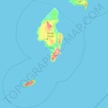
Name: Tinian Municipality topographic map, elevation, terrain.
Average elevation: 5 m
Minimum elevation: 0 m
Maximum elevation: 186 m
Make a donation
Gear up for your next adventure:
As an Amazon Associate, this site earns from qualifying purchases at no extra cost to you.
Other topographic maps
Click on a map to view its topography, its elevation and its terrain.
Bird Island Marine Protected Area
United States > Northern Mariana Islands > Saipan Municipality
Average elevation: 46 m
Mariana Islands
United States > Northern Mariana Islands > Northern Islands Municipality
Average elevation: 1 m
Anatahan Island
United States > Northern Mariana Islands > Northern Islands Municipality
Anatahan is roughly elliptical in shape, with a length of 9 kilometers (5.6 mi) and a width of 4 km (2.5 mi) and an area of 33.9 km2 (13.1 sq mi). The island is the summit of a stratovolcano which reaches an altitude of 790 m (2,592 ft) above sea level at its highest peak.
Average elevation: 94 m
Make a donation
Gear up for your next adventure:
As an Amazon Associate, this site earns from qualifying purchases at no extra cost to you.
Mariana Islands
United States > Northern Mariana Islands > Northern Islands Municipality
Average elevation: 1 m
Alamagan Island
United States > Northern Mariana Islands > Northern Islands Municipality
Alamagan is roughly elliptical in shape, with a length of 4.8 kilometers (3.0 mi), width of 4 km (2.5 mi), and area of 13 km2 (5.0 sq mi). The entire island is the summit of a stratovolcano which rises over 4,000 meters (13,120 ft) from the ocean floor, to an altitude of 744 m (2,441 ft) above sea level at…
Average elevation: 148 m
Make a donation
Gear up for your next adventure:
As an Amazon Associate, this site earns from qualifying purchases at no extra cost to you.
Northern Islands Municipality
United States > Northern Mariana Islands > Northern Islands Municipality
Average elevation: 8 m