
Make a donation
Gear up for your next adventure:
As an Amazon Associate, this site earns from qualifying purchases at no extra cost to you.
Uribia topographic map
Click on the map to display elevation.
Make a donation
Gear up for your next adventure:
As an Amazon Associate, this site earns from qualifying purchases at no extra cost to you.
Uribia
Uribia is a town and municipality of the La Guajira department of Colombia. It is the youngest municipality of this Department since the year 2000. Northern Zone of the Cerrejón coal mines are located in this municipality. The municipality also contains the Serranía de Macuira mountain range which is an isolated low altitude mountain range in the middle of La Guajira Desert. One third of this mountain range is also a National Natural Park of Colombia.
Make a donation
Gear up for your next adventure:
As an Amazon Associate, this site earns from qualifying purchases at no extra cost to you.
About this map
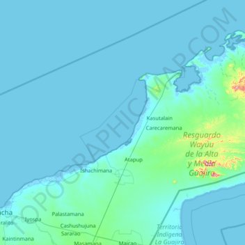
Name: Uribia topographic map, elevation, terrain.
Location: Uribia, La Guajira, 440029, Colombia (11.52523 -72.38007 12.45852 -71.11325)
Average elevation: 21 m
Minimum elevation: -6 m
Maximum elevation: 623 m
Make a donation
Gear up for your next adventure:
As an Amazon Associate, this site earns from qualifying purchases at no extra cost to you.
Other topographic maps
Click on a map to view its topography, its elevation and its terrain.
Maicao
Colombia > La Guajira > Maicao
The municipality of Maicao borders to the north with the municipalities of Uribia and Manaure; to the east with the Venezuela; to the south with the municipality of Albania and to the west with the municipality of Riohacha covering a total area of 1,782 km2 and at altitude over sea level of 52 m.
Average elevation: 51 m
Make a donation
Gear up for your next adventure:
As an Amazon Associate, this site earns from qualifying purchases at no extra cost to you.
Palomino
Colombia > La Guajira > Dibulla
Palomino is located in the municipality of Dibulla part of the department of Guajira and is only 2 meters above sea level. It is one of the five towns that form the municipality of Dibulla. It is located on the foothills of the Sierra Nevada Mountains of Colombia. The Sierra Nevada de Santa Marta, declared as…
Average elevation: 51 m