Geolocate

Joyabaj topographic map

Click on the map to display elevation.

About this map

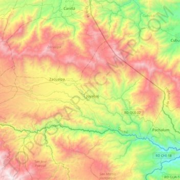
Name: Joyabaj topographic map, elevation, terrain.

Location: Joyabaj, Quiché, Guatemala (14.90701 -91.02457 15.10251 -90.65500)

Average elevation: 1,597 m

Minimum elevation: 672 m

Maximum elevation: 2,686 m

Other topographic maps

Click on a map to view its topography, its elevation and its terrain.

Playa Grande Ixcán

Guatemala > Quiché > Ixcán

Average elevation: 186 m

Gear up for your next adventure:

🧺Microfibre Travel Towels - Fast-drying and compact towels for wild swimming and camping
🧼Biodegradable Soap - Leave-no-trace hygiene for multi-day mountain treks
🧰Survival Kits - Emergency tools for remote environments
🧼Technical Clothing Wash - Special soap to clean and restore waterproof membranes
🎿Telescopic Trekking Poles - Reduces knee strain on steep topographic descents

As an Amazon Associate, this site earns from qualifying purchases at no extra cost to you.