
Rhede topographic map
Interactive map
Click on the map to display elevation.
About this map
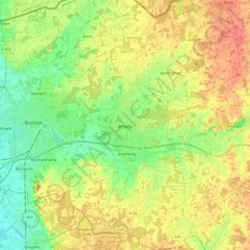
Name: Rhede topographic map, elevation, terrain.
Location: Rhede, Kreis Borken, Nordrhein-Westfalen, 46414, Deutschland (51.76849 6.64356 51.90547 6.76567)
Average elevation: 40 m
Minimum elevation: 19 m
Maximum elevation: 62 m
Der Ortskern der Stadt liegt auf einer Höhe von etwa 30 bis 32 m ü. NHN. Höchster Punkt liegt mit 51 m ü. NHN im äußersten Süden, der tiefste Punkt mit 26 m im Westen an der Grenze des Stadtgebiets zur Nachbarstadt Bocholt.
Other topographic maps
Click on a map to view its topography, its elevation and its terrain.
Borken
Deutschland > Nordrhein-Westfalen > Kreis Borken > Borken
Borken, Kreis Borken, Nordrhein-Westfalen, 46325, Deutschland
Average elevation: 56 m