
Thank you for supporting this site ❤️
Make a donation
Make a donation
Gear up for your next adventure:
As an Amazon Associate, this site earns from qualifying purchases at no extra cost to you.
Gaja topographic map
Click on the map to display elevation.
Thank you for supporting this site ❤️
Make a donation
Make a donation
Gear up for your next adventure:
As an Amazon Associate, this site earns from qualifying purchases at no extra cost to you.
About this map
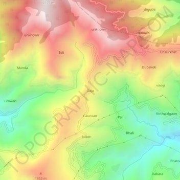
Name: Gaja topographic map, elevation, terrain.
Location: Gaja, Narendra Nagar, Tehri Garhwal, Uttarakhand, India (30.24896 78.40226 30.28896 78.44226)
Average elevation: 1,599 m
Minimum elevation: 1,009 m
Maximum elevation: 2,177 m
Thank you for supporting this site ❤️
Make a donation
Make a donation
Gear up for your next adventure:
As an Amazon Associate, this site earns from qualifying purchases at no extra cost to you.