
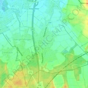
Recherswil topographic map
Interactive map
Click on the map to display elevation.
About this map
Name: Recherswil topographic map, elevation, terrain.
Average elevation: 463 m
Minimum elevation: 450 m
Maximum elevation: 481 m
Other topographic maps
Click on a map to view its topography, its elevation and its terrain.
Lohn-Ammannsegg
Schweiz > Solothurn > Amtei Bucheggberg-Wasseramt
Lohn-Ammannsegg, Bezirk Wasseramt, Amtei Bucheggberg-Wasseramt, Solothurn, 4573, Schweiz
Average elevation: 507 m
Lüsslingen-Nennigkofen
Schweiz > Solothurn > Amtei Bucheggberg-Wasseramt
Lüsslingen-Nennigkofen, Bezirk Bucheggberg, Amtei Bucheggberg-Wasseramt, Solothurn, 4574, Schweiz
Average elevation: 471 m
Buchegg
Schweiz > Solothurn > Amtei Bucheggberg-Wasseramt
Buchegg, Bezirk Bucheggberg, Amtei Bucheggberg-Wasseramt, Solothurn, 4586, Schweiz
Average elevation: 534 m