
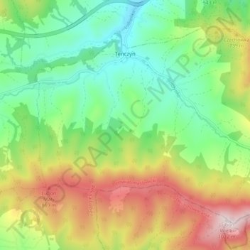
Tenczyn topographic map
Interactive map
Click on the map to display elevation.
About this map
Name: Tenczyn topographic map, elevation, terrain.
Average elevation: 620 m
Minimum elevation: 381 m
Maximum elevation: 1,008 m
Other topographic maps
Click on a map to view its topography, its elevation and its terrain.
Pcim
Poland > Lesser Poland Voivodeship > Myślenice County
Pcim, gmina Pcim, Myślenice County, Lesser Poland Voivodeship, 32-432, Poland
Average elevation: 483 m
Myślenice
Poland > Lesser Poland Voivodeship > Myślenice County
Myślenice, gmina Myślenice, Myślenice County, Lesser Poland Voivodeship, 32-400, Poland
Average elevation: 384 m
Myślenice
Poland > Lesser Poland Voivodeship > Myślenice County > Myślenice > Myślenice
Myślenice, gmina Myślenice, Myślenice County, Lesser Poland Voivodeship, 32-400, Poland
Average elevation: 374 m