
Make a donation
Gear up for your next adventure:
As an Amazon Associate, this site earns from qualifying purchases at no extra cost to you.
Tumaco topographic map
Click on the map to display elevation.
Make a donation
Gear up for your next adventure:
As an Amazon Associate, this site earns from qualifying purchases at no extra cost to you.
Tumaco
Tumaco está a una altitud de dos metros sobre el nivel del mar. El municipio presenta en toda su extensión diferentes relieves, desde el montañoso en inmediaciones andinas del piedemonte costero hasta la llanura del Pacífico. Son accidentes geográficos importantes la bahía de Tumaco, el ancón de Sardinas, el cabo Manglares y la isla de El Morro, entre otros.
Make a donation
Gear up for your next adventure:
As an Amazon Associate, this site earns from qualifying purchases at no extra cost to you.
About this map
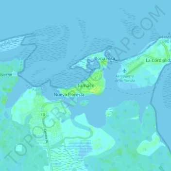
Name: Tumaco topographic map, elevation, terrain.
Location: Tumaco, Pacífico Sur, Nariño, Colombia (1.76776 -78.81060 1.84776 -78.73060)
Average elevation: 1 m
Minimum elevation: -3 m
Maximum elevation: 11 m
Make a donation
Gear up for your next adventure:
As an Amazon Associate, this site earns from qualifying purchases at no extra cost to you.