
Lofer topographic map
Interactive map
Click on the map to display elevation.
About this map
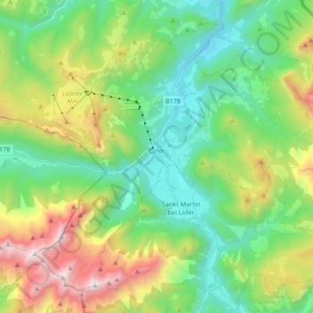
Name: Lofer topographic map, elevation, terrain.
Location: Lofer, Bezirk Zell am See, Salzburg, 5090, Österreich (47.53642 12.62818 47.63280 12.79541)
Average elevation: 1,155 m
Minimum elevation: 546 m
Maximum elevation: 2,481 m
Other topographic maps
Click on a map to view its topography, its elevation and its terrain.
Hinterglemm
Österreich > Salzburg > Bezirk Zell am See > Saalbach-Hinterglemm
Hinterglemm, Saalbach-Hinterglemm, Bezirk Zell am See, Salzburg, 5754, Österreich
Average elevation: 1,392 m
Piesendorf
Österreich > Salzburg > Bezirk Zell am See
Piesendorf, Bezirk Zell am See, Salzburg, 5721, Österreich
Average elevation: 1,278 m
Rauris
Österreich > Salzburg > Bezirk Zell am See
Rauris, Bezirk Zell am See, Salzburg, 5661, Österreich
Average elevation: 1,791 m
Saalbach-Hinterglemm
Österreich > Salzburg > Bezirk Zell am See > Saalbach-Hinterglemm
Saalbach-Hinterglemm, Bezirk Zell am See, Salzburg, Österreich
Average elevation: 1,517 m
Zell am See
Österreich > Salzburg > Bezirk Zell am See
Zell am See, Bezirk Zell am See, Salzburg, 5700, Österreich
Average elevation: 1,118 m