Geolocate

Érd topographic map

Click on the map to display elevation.

About this map

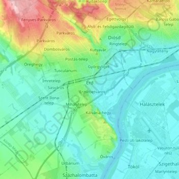
Name: Érd topographic map, elevation, terrain.

Location: Érd, Érdi járás, Pest, Central Hungary, Hungary (47.31453 18.83387 47.43021 18.96238)

Average elevation: 138 m

Minimum elevation: 93 m

Maximum elevation: 290 m

Other topographic maps

Click on a map to view its topography, its elevation and its terrain.

Pannonian Basin

Hungary > Pest > Cegléd

Pannonian basin vs Carpathian basin: On the territory of present-day Hungary the ancient Roman Pannonia province was located only on Transdanubian territories, however the Great Hungarian Plain was not part of Pannonia province. This comprises less than 29% of modern Hungary, therefore Hungarian geographers…

Average elevation: 99 m

Felsőnyáregyháza

Hungary > Pest > Nyáregyháza

Average elevation: 137 m

Börzsöny

Hungary > Pest

Average elevation: 249 m

Székhegy

Hungary > Pest > Vác

Average elevation: 145 m

Malomi-dűlő

Hungary > Pest > Páty

Average elevation: 181 m

Benta

Hungary > Pest > Érd

Average elevation: 132 m

Homokpusztai gyep TVT

Hungary > Pest > Pusztavacs

Average elevation: 132 m

Tahi

Hungary > Pest

Average elevation: 161 m

Érd

Hungary > Pest > Érd > Érd

Average elevation: 133 m

Szentendre

Hungary > Pest > Szentendre > Szentendre

Average elevation: 137 m

Göd

Hungary > Pest > Göd > Göd

Average elevation: 124 m

Fót

Hungary > Pest > Fót > Fót

Average elevation: 174 m

Gear up for your next adventure:

🎒Hiking Backpacks - Comfortable backpacks for day hikes and multi-day treks
🧢Thermal Beanie Hats - Prevent heat loss from the head in windy summit conditions
🕶️Glacier Goggles - Maximum protection for high-altitude snow topography
❄️Walking Crampons - Added traction for icy slopes and winter peak bagging
🧤Waterproof Overmitts - Extreme weather protection for hikers and mountaineers

As an Amazon Associate, this site earns from qualifying purchases at no extra cost to you.