
Vichada topographic map
Interactive map
Click on the map to display elevation.
About this map
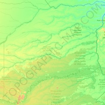
Name: Vichada topographic map, elevation, terrain.
Location: Vichada, RAP Llanos, Colombia (2.73675 -71.07780 6.32878 -67.40844)
Average elevation: 124 m
Minimum elevation: 39 m
Maximum elevation: 685 m
Other topographic maps
Click on a map to view its topography, its elevation and its terrain.
Medellín
Colombia > Antioquia > Medellín
Medellín has 16 comunas (districts), 5 corregimientos (townships), and 271 barrios (neighborhoods). The metropolitan area of Medellín lies within the Aburrá valley at an elevation of 1,500 metres (4,900 feet) above sea level and is bisected by the Medellín River (also called Porce), which flows northward.…
Average elevation: 2,098 m
Bogota
The city is located in the center of Colombia, on a high plateau known as the Bogotá savanna, part of the Altiplano Cundiboyacense located in the Eastern Cordillera of the Andes. Its altitude averages 2,640 meters (8,660 ft) above sea level. Subdivided into 20 localities, Bogotá has an area of 1,587 square…
Average elevation: 2,735 m
Andes
Andes is a municipality and town in the Antioquia Department, Colombia. Part of the sub-region of Southwestern Antioquia, it is located on the western Colombian Andes mountain range. Andes was founded on 13 March 1852 by Pedro Antonio Restrepo Escobar. Its elevation is 1,360 metres above sea level with an…
Average elevation: 1,559 m
Nariño
Nariño has a diverse geography and varied climate according to altitude: hot in the plains of the Pacific and cold in the mountains, where most of the population resides, a situation that is repeated in a north-south direction. Other important cities include Tumaco and Ipiales.
Average elevation: 1,156 m
Campamento
Colombia > Antioquia > Campamento
Campamento is a town and municipality in the Colombian department of Antioquia. Part of the subregion of Northern Antioquia, it lies at an altitude of 1,700 m (5,600 ft) above sea level. It is a little town, in the middle of the Andes.It borders on the north with the municipalities of Yarumal and Anorí, on…
Average elevation: 1,607 m
Yumbo
Yumbo has a relatively dry but extremely foggy and sunless tropical savanna climate (Köppen Aw) not unlike the climate of Bogotá except substantially hotter due to the lower elevation.
Average elevation: 1,251 m
Garagoa
Garagoa (Spanish pronunciation: [ɡaɾaˈɣoa]) is a town and municipality in Colombia, located in the Boyacá Department. It covers an area of 191.75 km2 and the urban centre is located at an altitude of 1,650 metres (5,410 ft) above sea level. Parts of the municipality reach altitudes of 3,050 metres (10,010…
Average elevation: 1,988 m
La Pintada
La Pintada (Spanish pronunciation: [la pinˈtaða]); is a town and municipality in the southwest region of the Antioquia department. It is located 79 miles from Medellín at an altitude of 600 m (2,000 ft) above sea level. It borders the Fredonia and Santa Bárbara municipalities to the north. The Cauca River…
Average elevation: 816 m
Funza
Funza (Spanish pronunciation: [ˈfunsa]) is a municipality and town of Colombia in the Western Savanna Province, of the department of Cundinamarca. Funza is situated on the Bogotá savanna, the southwestern part of the Altiplano Cundiboyacense with the urban centre at an altitude of 2,548 metres (8,360 ft). In…
Average elevation: 2,551 m
Perímetro Urbano Valledupar
Colombia > Cesar > Valledupar
Valledupar is located southeast of the Sierra Nevada de Santa Marta. Its average temperature is 28 °C. Because of its relatively high altitude and proximity to the equator, it has a variety of environments, from warm heat to perpetual snow. Notable geographic features in Valledupar include the Sierra Nevada…
Average elevation: 163 m
Líbano
Líbano is located in the Cordillera Central, east of Nevado del Ruiz. The town is at an altitude of 1,565 metres (5,135 ft) above sea level, putting it in the tierra templada, or temperate zone, of Colombia. The area is hilly and heavily forested where it is not used for agriculture. Agriculture in the area…
Average elevation: 1,687 m
Caucasia
Colombia > Antioquia > Caucasia
The municipality of Caucasia is located at the northern department of Antioquia, on the border with the department of Córdoba and the subregion of Bajo Cauca Antioquia. It lies at an altitude of 150 m (490 ft) above sea level. Its territory is a flat area with small ridges in the north and west and south. It…
Average elevation: 63 m
Gómez Plata
Gómez Plata has a cool tropical rainforest climate (Af) due to altitude. It has very heavy rainfall year round.
Average elevation: 1,644 m
Leticia
Leticia (Spanish pronunciation: [leˈtisja]) is the southernmost city in the Republic of Colombia, capital of the department of Amazonas, Colombia's southernmost town (4.09° south 69.57° west) and one of the major ports on the Amazon River. It has an elevation of 96 meters (315') above sea level and an…
Average elevation: 71 m
Sabaneta
Colombia > Antioquia > Sabaneta
Its topography varies from flat reliefs and slight hills to places with steep slopes. Its most notable heights are those of Piedras Blancas (2,650 mamsl) in La Romera, the Cuchilla Santa Teresa (2,200 mamsl), the hill of Los Gallinazos in Pan de Azúcar (1,800 mamsl), the hill Morrón, La Siberia and the Ancón.
Average elevation: 1,787 m
Palomino
Colombia > La Guajira > Dibulla
Palomino is located in the municipality of Dibulla part of the department of Guajira and is only 2 meters above sea level. It is one of the five towns that form the municipality of Dibulla. It is located on the foothills of the Sierra Nevada Mountains of Colombia. The Sierra Nevada de Santa Marta, declared as…
Average elevation: 51 m
Pitalito
The valley itself lies at about 1,300 meters above sea level. All the surrounding mountains grow coffee with the average farm having about 6 hectares and about 5,000 trees per hectare. The soil is volcanic, providing plenty of organic nutrients for the high altitude coffee.
Average elevation: 1,635 m
Manizales
Manizales is the capital city of one of the smallest Colombian departments. The city is described as having an "abrupt topography", and lies on the Colombian Central Mountain Range (part of the longest continental mountain range, the Andes), with a great deal of ridgelines and steep slopes, which, combined…
Average elevation: 2,114 m
Facatativá
Facatativá's main source of income is agriculture. Because of its altitude (2586 m) above sea level, Facatativá is a convenient place for growing flowers. The Floral industry is in fact the most important industry in Facatativá providing employment to a big part of the population. Seasonal jobs in the…
Average elevation: 2,622 m
Sogamoso
Sogamoso (Spanish pronunciation: [soɣaˈmoso]) is a city in the department of Boyacá of Colombia. It is the capital of the Sugamuxi Province, named after the original Sugamuxi. Sogamoso is nicknamed "City of the Sun", based on the original Muisca tradition of pilgrimage and adoring their Sun god Sué at the…
Average elevation: 2,901 m
Istmina
Istmina is a municipality and town in the Chocó Department, Colombia. The town of Istmina was founded in 1834 by Juan Nepomuceno Mosquera, initially with the name of San Pablo. The name was changed in 1903 to Istmina, a contraction of isthmus and minas (mines), two characteristics of the area. The…
Average elevation: 381 m