
Make a donation
Gear up for your next adventure:
As an Amazon Associate, this site earns from qualifying purchases at no extra cost to you.
Daraban Tehsil topographic map
Click on the map to display elevation.
Make a donation
Gear up for your next adventure:
As an Amazon Associate, this site earns from qualifying purchases at no extra cost to you.
Daraban Tehsil
Daraban is a tehsil located in Dera Ismail Khan District, Khyber Pakhtunkhwa, Pakistan. It is located at 31°44'3N 70°20'11E and has an altitude of 221 metres (725 ft). Daraban is a small town which lies 40 miles (64 km) west of Dera Ismail khan in the foothills of Sulaiman Mountains. Daraban region has a rich, fascinating history. Over the last two decades or so, Daraban has seen massive growth, becoming a vibrant hub of local trade and business.This has led to influx of economic migrants from neighboring villages, who have begin to settle in outskirts of Daraban, causing an increase in Town's population. Daraban enjoys excellent geographical condition, it lies on major national highway connecting Khyber Pakhtunkhuwa and Punjab with eastern parts of Balochistan.The town recent history includes events like high profile insurgent led attack on Draban's police station which led to deaths of 23 security personnels. This was only occasion when town gained media attention in Pakistan and abroad. December 12,2023 attack and more recent one in Chaudwan on February 5,2024 reflect heightened security threats in the region.
Make a donation
Gear up for your next adventure:
As an Amazon Associate, this site earns from qualifying purchases at no extra cost to you.
About this map
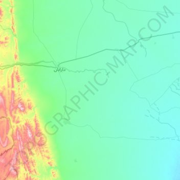
Name: Daraban Tehsil topographic map, elevation, terrain.
Average elevation: 272 m
Minimum elevation: 163 m
Maximum elevation: 925 m
Make a donation
Gear up for your next adventure:
As an Amazon Associate, this site earns from qualifying purchases at no extra cost to you.
Other topographic maps
Click on a map to view its topography, its elevation and its terrain.
Dera Ismail Khan
Pakistan > Khyber Pakhtunkhwa > Dera Ismail Khan District
D. I Khan is situated at an altitude of 177 metres above sea level.
Average elevation: 177 m
Dera Ismail Khan
Pakistan > Khyber Pakhtunkhwa > Dera Ismail Khan District
D. I Khan is situated at an altitude of 177 metres above sea level.
Average elevation: 177 m
Make a donation
Gear up for your next adventure:
As an Amazon Associate, this site earns from qualifying purchases at no extra cost to you.