
Fruitland topographic map
Interactive map
Click on the map to display elevation.
About this map
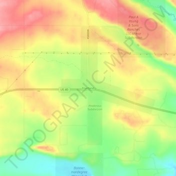
Name: Fruitland topographic map, elevation, terrain.
Location: Fruitland, Duchesne County, Utah, 84027, United States (40.19273 -110.85961 40.23273 -110.81961)
Average elevation: 2,028 m
Minimum elevation: 1,971 m
Maximum elevation: 2,075 m
Other topographic maps
Click on a map to view its topography, its elevation and its terrain.
Roosevelt
United States > Utah > Duchesne County
Roosevelt is situated on U.S. Route 40 in the northeast corner of the state, south of the Uinta Mountains, at an elevation of 5,250 feet (1,600 m). The town was incorporated at a mass meeting of 44 citizens on 21 February 1913. From 1906 to 1914 Roosevelt was in Wasatch County, but in 1914 Duchesne County was…
Average elevation: 1,553 m