
Cortanovci topographic map
Interactive map
Click on the map to display elevation.
About this map
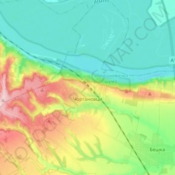
Name: Cortanovci topographic map, elevation, terrain.
Average elevation: 130 m
Minimum elevation: 64 m
Maximum elevation: 271 m
Other topographic maps
Click on a map to view its topography, its elevation and its terrain.
Брдеж до
Serbia > Vojvodina > Srem Administrative District > Indjija Municipality > Cortanovci
Average elevation: 215 m
Maradik
Serbia > Vojvodina > Srem Administrative District > Indjija Municipality
Average elevation: 157 m
Beska
Serbia > Vojvodina > Srem Administrative District > Indjija Municipality
Average elevation: 128 m
Indjija
Serbia > Vojvodina > Srem Administrative District > Indjija Municipality
Average elevation: 110 m