
Make a donation
Gear up for your next adventure:
As an Amazon Associate, this site earns from qualifying purchases at no extra cost to you.
Greenleaf State Park topographic map
Click on the map to display elevation.
Make a donation
Gear up for your next adventure:
As an Amazon Associate, this site earns from qualifying purchases at no extra cost to you.
Greenleaf State Park
According to Caneday et al., the normal elevation of Greenleaf Lake is 510 feet (160 m) above sealevel, and the surface area is 920 acres (3.7 km2). The capacity is rated at 14,720 acre-feet (18,160,000 m3). The shoreline is 14 miles (23 km).
Make a donation
Gear up for your next adventure:
As an Amazon Associate, this site earns from qualifying purchases at no extra cost to you.
About this map
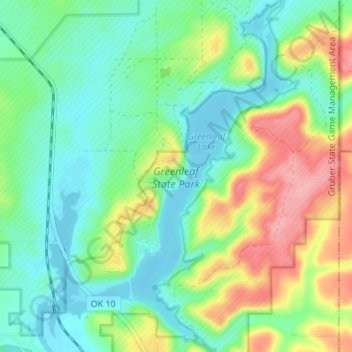
Name: Greenleaf State Park topographic map, elevation, terrain.
Average elevation: 186 m
Minimum elevation: 149 m
Maximum elevation: 260 m
Make a donation
Gear up for your next adventure:
As an Amazon Associate, this site earns from qualifying purchases at no extra cost to you.
Other topographic maps
Click on a map to view its topography, its elevation and its terrain.