Geolocate

Vir topographic map

Click on the map to display elevation.

About this map

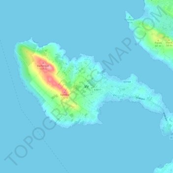
Name: Vir topographic map, elevation, terrain.

Location: Vir, Općina Vir, Zadar County, 23234, Croatia (44.28032 15.01767 44.32856 15.13532)

Average elevation: 8 m

Minimum elevation: -3 m

Maximum elevation: 111 m

Other topographic maps

Click on a map to view its topography, its elevation and its terrain.

Gear up for your next adventure:

🔋Solar Chargers - Eco-friendly charging solutions for outdoor use
🔦Waterproof LED Headlamps - Hands-free lighting for evening treks and emergency navigation
🪓Outdoor Multitools - Versatile tools for hiking and camping
Insulated Travel Mugs - Keep drinks hot while surveying the landscape from a summit
🥤Hiking Water Bottles - Reusable bottles for hydration on the trail

As an Amazon Associate, this site earns from qualifying purchases at no extra cost to you.