Geolocate

Hidalgo topographic map

Click on the map to display elevation.

About this map

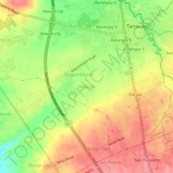
Name: Hidalgo topographic map, elevation, terrain.

Location: Hidalgo, Tanauan, Batangas, Calabarzon, 4232, Philippines (14.05137 121.12075 14.09137 121.16075)

Average elevation: 163 m

Minimum elevation: 111 m

Maximum elevation: 202 m

Gear up for your next adventure:

🧦Hiking Socks - Breathable socks designed to prevent blisters on long walks
👕Technical Hiking Tees - Moisture-management for high-exertion climbs
🦯Walking Poles - Supportive poles for long-distance walking
🧥Softshell Jackets - Breathable jackets for active outdoor use
Lightweight Solo Tents - Backpacking tents designed for wild camping in the UK highlands

As an Amazon Associate, this site earns from qualifying purchases at no extra cost to you.