Geolocate

Cherni Vit topographic map

Click on the map to display elevation.

About this map

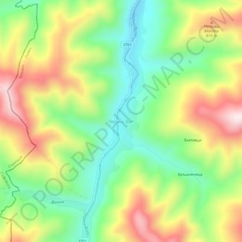
Name: Cherni Vit topographic map, elevation, terrain.

Location: Cherni Vit, Teteven, Lovech, Bulgaria (42.86176 24.17552 42.90176 24.21552)

Average elevation: 643 m

Minimum elevation: 423 m

Maximum elevation: 940 m

Other topographic maps

Click on a map to view its topography, its elevation and its terrain.

Central Balkan National Park

Bulgaria > Lovech

Average elevation: 646 m

Beli Osam

Bulgaria > Lovech

Average elevation: 892 m

Oreshak

Bulgaria > Lovech

Average elevation: 556 m

Troyan

Bulgaria > Lovech

Average elevation: 640 m

Gear up for your next adventure:

👟Heavy Duty Boot Laces - Always carry a spare for your hiking footwear
🔥Emergency Fire Starters - Reliable ignition tools for survival situations in damp conditions
🍳Camping Stoves - Compact stoves for outdoor cooking
🚲Cycling GPS Computers - Track elevation and topographic routes on two wheels
🔋Lithium AA Batteries - Long-lasting power that performs well in cold mountain weather

As an Amazon Associate, this site earns from qualifying purchases at no extra cost to you.