
Mercer County topographic map
Interactive map
Click on the map to display elevation.
About this map
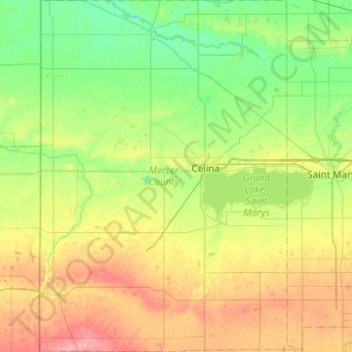
Name: Mercer County topographic map, elevation, terrain.
Location: Mercer County, Ohio, United States of America (40.35194 -84.80424 40.72815 -84.43420)
Average elevation: 271 m
Minimum elevation: 236 m
Maximum elevation: 336 m
According to the U.S. Census Bureau, the county has a total area of 473 square miles (1,230 km2), of which 462 square miles (1,200 km2) is land and 11 square miles (28 km2) (2.3%) is water. The entire county has an elevation difference of less than 300 feet. The highest point is on the southern county line at 1071 feet above sea level. This is in proximity to the head waters for the Wabash River. The lowest point in the county is 780 feet above sea level. This point is located on the northern county line where the St. Marys River crosses over.
Other topographic maps
Click on a map to view its topography, its elevation and its terrain.
Defiance County
United States of America > Ohio
Defiance County, Ohio, United States of America
Average elevation: 225 m
Hocking County
United States of America > Ohio
Hocking County, Ohio, United States of America
Average elevation: 281 m
Preble County
United States of America > Ohio
Preble County, Ohio, United States of America
Average elevation: 315 m
Pickaway County
United States of America > Ohio
Pickaway County, Ohio, United States of America
Average elevation: 246 m
Champaign County
United States of America > Ohio
Champaign County, Ohio, United States of America
Average elevation: 342 m
Chesterland
United States of America > Ohio > Chesterland
Chesterland, Chester Township, Geauga County, Ohio, 44026, United States of America
Average elevation: 356 m
Logan County
United States of America > Ohio
Logan County, Ohio, United States of America
Average elevation: 340 m
Boardman
United States of America > Ohio > Boardman
Boardman, Mahoning County, Ohio, 44512, United States of America
Average elevation: 323 m
Wyandot County
United States of America > Ohio
Wyandot County, Ohio, United States of America
Average elevation: 267 m
Morgan County
United States of America > Ohio
Morgan County, Ohio, United States of America
Average elevation: 267 m
Erie County
United States of America > Ohio
Erie County, Ohio, United States of America
Average elevation: 185 m
Canfield
United States of America > Ohio > Canfield
Canfield, Mahoning, Ohio, 44406, United States of America
Average elevation: 347 m
Upper Arlington
United States of America > Ohio > Upper Arlington
Upper Arlington, Franklin County, Ohio, United States of America
Average elevation: 249 m
Jefferson County
United States of America > Ohio
Jefferson County, Ohio, United States of America
Average elevation: 335 m
Auglaize County
United States of America > Ohio
Auglaize County, Ohio, United States of America
Average elevation: 285 m
Noble County
United States of America > Ohio
Noble County, Ohio, United States of America
Average elevation: 287 m
Meigs County
United States of America > Ohio
Meigs County, Ohio, United States of America
Average elevation: 226 m
Crawford County
United States of America > Ohio
Crawford County, Ohio, United States of America
Average elevation: 313 m
Northwood
United States of America > Ohio > Northwood
Northwood, Wood County, Ohio, United States of America
Average elevation: 187 m
Hancock County
United States of America > Ohio
Hancock County, Ohio, United States of America
Average elevation: 250 m
Clinton County
United States of America > Ohio
Clinton County, Ohio, United States of America
Average elevation: 308 m
Fayette County
United States of America > Ohio
Fayette County, Ohio, United States of America
Average elevation: 299 m
Belmont
United States of America > Ohio
Belmont, Ohio, United States of America
Average elevation: 338 m
Hardin County
United States of America > Ohio
Hardin County, Ohio, United States of America
Average elevation: 301 m
Seneca County
United States of America > Ohio
Seneca County, Ohio, United States of America
Average elevation: 246 m
Washington County
United States of America > Ohio
Washington County, Ohio, United States of America
Average elevation: 256 m
Monroe County
United States of America > Ohio
Monroe County, Ohio, United States of America
Average elevation: 311 m
Richland County
United States of America > Ohio
Richland County, Ohio, United States of America
Average elevation: 362 m
McDonald
United States of America > Ohio > McDonald
McDonald, Trumbull County, Ohio, 44437, United States of America
Average elevation: 285 m
Madeira
United States of America > Ohio > Madeira
Madeira, Hamilton County, Ohio, United States of America
Average elevation: 251 m
Central Business District
United States of America > Ohio > Cincinnati
Central Business District, Cincinnati, Hamilton County, Ohio, 45202-2209, United States of America
Average elevation: 166 m
Shelby County
United States of America > Ohio
Shelby County, Ohio, United States of America
Average elevation: 310 m
Marion County
United States of America > Ohio
Marion County, Ohio, United States of America
Average elevation: 291 m
Sycamore
United States of America > Ohio > Sycamore
Sycamore, Sycamore Township, Hamilton County, Ohio, 45249, United States of America
Average elevation: 252 m
Mosquito Creek
United States of America > Ohio
Mosquito Creek, Trumbull, Ohio, 44484, United States of America
Average elevation: 294 m
Henry County
United States of America > Ohio
Henry County, Ohio, United States of America
Average elevation: 213 m
Morrow County
United States of America > Ohio
Morrow County, Ohio, United States of America
Average elevation: 352 m
Port Washington
United States of America > Ohio > Port Washington
Port Washington, Tuscarawas County, Ohio, United States of America
Average elevation: 270 m
Glanntown
United States of America > Ohio > Glanntown
Glanntown, Lucas, Ohio, 43617, United States of America
Average elevation: 203 m
Roads
United States of America > Ohio > Roads
Roads, Jackson County, Ohio, 45692, United States of America
Average elevation: 238 m
Fountain Park
United States of America > Ohio > Fountain Park
Fountain Park, Champaign County, Ohio, 43084, United States of America
Average elevation: 336 m
Brecksville
United States of America > Ohio > Brecksville
Brecksville, Cuyahoga County, Ohio, 44141, United States of America
Average elevation: 292 m
Sawyer Point Park
United States of America > Ohio > Cincinnati
Sawyer Point Park, Lytle Park Historic District, Cincinnati, Hamilton County, Ohio, United States of America
Average elevation: 166 m
Tiffin
United States of America > Ohio > Tiffin
Tiffin, Seneca County, Ohio, 44883, United States of America
Average elevation: 233 m
Zoar
United States of America > Ohio > Zoar
Zoar, Tuscarawas County, Ohio, 44697, United States of America
Average elevation: 289 m
Columbia Township
United States of America > Ohio
Columbia Township, Hamilton County, Ohio, 45227-3340, United States of America
Average elevation: 206 m