
Packington topographic map
Click on the map to display elevation.
About this map
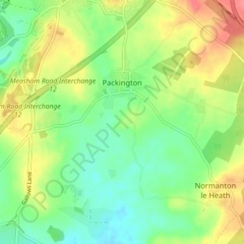
Name: Packington topographic map, elevation, terrain.
Average elevation: 119 m
Minimum elevation: 92 m
Maximum elevation: 156 m
Leicestershire trails, hiking, mountain biking, running and outdoor activities
Other topographic maps
Click on a map to view its topography, its elevation and its terrain.
Kelham Bridge Nature Reserve
United Kingdom > England > Leicestershire > North West Leicestershire > Ravenstone
Average elevation: 139 m
Coalville
United Kingdom > England > Leicestershire > North West Leicestershire
Average elevation: 149 m
Isley Walton
United Kingdom > England > Leicestershire > North West Leicestershire
Average elevation: 76 m
Thringstone
United Kingdom > England > Leicestershire > North West Leicestershire
Average elevation: 126 m
Lount Wood
United Kingdom > England > Leicestershire > North West Leicestershire > Lount
Average elevation: 131 m
Breedon on the Hill
United Kingdom > England > Leicestershire > North West Leicestershire
Average elevation: 84 m
Ravenstone
United Kingdom > England > Leicestershire > North West Leicestershire
Average elevation: 143 m
Nailstone Colliery Railway
United Kingdom > England > Leicestershire > North West Leicestershire > Ibstock
Average elevation: 155 m
Sence Valley Country Park
United Kingdom > England > Leicestershire > North West Leicestershire > Heather
Average elevation: 131 m
Long Whatton
United Kingdom > England > Leicestershire > North West Leicestershire
Average elevation: 63 m
Timberwood Hill
United Kingdom > England > Leicestershire > North West Leicestershire
Average elevation: 192 m
Breedon Cloud Wood
United Kingdom > England > Leicestershire > North West Leicestershire > Breedon on the Hill
Average elevation: 90 m
Swannymote Rock
United Kingdom > England > Leicestershire > North West Leicestershire > Coalville
Average elevation: 139 m
Willesley Woods
United Kingdom > England > Leicestershire > North West Leicestershire > Ashby-de-la-Zouch > Willesley
Average elevation: 108 m
Kegworth
United Kingdom > England > Leicestershire > North West Leicestershire
Average elevation: 47 m
Diseworth
United Kingdom > England > Leicestershire > North West Leicestershire
Average elevation: 77 m
Hugglescote
United Kingdom > England > Leicestershire > North West Leicestershire
Average elevation: 154 m
Bardon Hill
United Kingdom > England > Leicestershire > North West Leicestershire
Average elevation: 199 m
Ashby de la Zouch Canal
United Kingdom > England > Leicestershire > North West Leicestershire > Moira
Average elevation: 100 m
Lockington
United Kingdom > England > Leicestershire > North West Leicestershire
Average elevation: 47 m
Albert Village
United Kingdom > England > Leicestershire > North West Leicestershire
Average elevation: 113 m
Oaks in Charnwood
United Kingdom > England > Leicestershire > North West Leicestershire
Average elevation: 155 m
Ellistown
United Kingdom > England > Leicestershire > North West Leicestershire
Average elevation: 153 m
Donington Le Heath
United Kingdom > England > Leicestershire > North West Leicestershire
Average elevation: 148 m
Shellbrook
United Kingdom > England > Leicestershire > North West Leicestershire > Ashby-de-la-Zouch > Blackfordby
Average elevation: 128 m
Oakthorpe
United Kingdom > England > Leicestershire > North West Leicestershire
Average elevation: 94 m
Donisthorpe
United Kingdom > England > Leicestershire > North West Leicestershire
From: A Topographical Dictionary of England, published by S Lewis, London, 1848.
Average elevation: 94 m
Ashby de la Zouch Canal
United Kingdom > England > Leicestershire > North West Leicestershire > Oakthorpe
Average elevation: 97 m
Cademan Wood
United Kingdom > England > Leicestershire > North West Leicestershire > Whitwick
Average elevation: 138 m
Newbold
United Kingdom > England > Leicestershire > North West Leicestershire
Average elevation: 114 m
Peggs Green
United Kingdom > England > Leicestershire > North West Leicestershire > Peggs Green
Average elevation: 121 m
Griffydam
United Kingdom > England > Leicestershire > North West Leicestershire
Average elevation: 111 m
Farmtown
United Kingdom > England > Leicestershire > North West Leicestershire > Coleorton
Average elevation: 141 m
Willesley
United Kingdom > England > Leicestershire > North West Leicestershire
Average elevation: 110 m
Coalville
United Kingdom > England > Leicestershire > North West Leicestershire
Average elevation: 149 m
Coalville
United Kingdom > England > Leicestershire > North West Leicestershire
Average elevation: 149 m
Coalville
United Kingdom > England > Leicestershire > North West Leicestershire
Average elevation: 149 m
Isley Walton
United Kingdom > England > Leicestershire > North West Leicestershire
Average elevation: 76 m
Coalville
United Kingdom > England > Leicestershire > North West Leicestershire
Average elevation: 149 m