
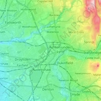
Ashton-under-Lyne topographic map
Interactive map
Click on the map to display elevation.
About this map
Name: Ashton-under-Lyne topographic map, elevation, terrain.
Average elevation: 129 m
Minimum elevation: 63 m
Maximum elevation: 306 m
At 53°29′38″N 2°6′11″W / 53.49389°N 2.10306°W / 53.49389; -2.10306 (53.4941°, −2.1032°), and 160 miles (257 km) north-northwest of London, Ashton-under-Lyne stands on the north bank of the River Tame, about 35 feet (11 m) above the river. Described in Samuel Lewis's A Topographical Dictionary of England (1848) as situated "on a gentle declivity", Ashton-under-Lyne lies on undulating ground by the Pennines, reaching a maximum elevation of about 1,000 feet (305 m) above sea level. It is 6.2 miles (10.0 km) east of Manchester city centre, and is bound on all sides by other towns: Audenshaw, Droylsden, Dukinfield, Mossley, Oldham, and Stalybridge, with little or no green space between them. Ashton experiences a temperate maritime climate, like much of the British Isles.
Other topographic maps
Click on a map to view its topography, its elevation and its terrain.
Millbrook
United Kingdom > England > Tameside
Millbrook, Tameside, Greater Manchester, England, SK15 3BG, United Kingdom
Average elevation: 215 m
Stocks
United Kingdom > England > Tameside > Millbrook
Stocks, Millbrook, Tameside, Greater Manchester, England, SK15 2TQ, United Kingdom
Average elevation: 202 m
Hattersley
United Kingdom > England > Tameside
Hattersley, Tameside, Greater Manchester, England, SK14 3EH, United Kingdom
Average elevation: 181 m
Stalybridge
United Kingdom > England > Tameside
Stalybridge, Tameside, Greater Manchester, England, SK15 1JU, United Kingdom
Average elevation: 180 m
River Tame
United Kingdom > England > Tameside
River Tame, Tameside, Greater Manchester, England, United Kingdom
Average elevation: 191 m
Audenshaw
United Kingdom > England > Tameside
Audenshaw, Tameside, Greater Manchester, England, M34 5PB, United Kingdom
Average elevation: 102 m
Mossley Cross
United Kingdom > England > Tameside > Mossley
Mossley Cross, Mossley, Tameside, Greater Manchester, England, OL5 0JB, United Kingdom
Average elevation: 195 m
Carrbrook
United Kingdom > England > Tameside
Carrbrook, Tameside, Greater Manchester, England, SK15 3SE, United Kingdom
Average elevation: 256 m
Haughton Green
United Kingdom > England > Tameside > Haughton Green
Haughton Green, Tameside, Greater Manchester, England, M34 7PD, United Kingdom
Average elevation: 107 m
Newtonmoor
United Kingdom > England > Tameside
Newtonmoor, Tameside, Greater Manchester, England, SK14 4LX, United Kingdom
Average elevation: 135 m
Mossley
United Kingdom > England > Tameside > Carrbrook
Mossley, Carrbrook, Tameside, Greater Manchester, England, United Kingdom
Average elevation: 251 m
Hyde
United Kingdom > England > Tameside
Hyde, Tameside, Greater Manchester, England, SK14 2QT, United Kingdom
Average elevation: 138 m
Werneth Low
United Kingdom > England > Tameside
Werneth Low, Tameside, Greater Manchester, England, SK14 3AA, United Kingdom
Average elevation: 175 m
Denton
United Kingdom > England > Tameside
Denton, Tameside, Greater Manchester, England, M34 2AA, United Kingdom
Average elevation: 106 m
Mottram
United Kingdom > England > Tameside
Mottram, Tameside, Greater Manchester, England, SK14 6TD, United Kingdom
Average elevation: 194 m
Droylsden
United Kingdom > England > Tameside
Droylsden, Tameside, Greater Manchester, England, M43 6GN, United Kingdom
Average elevation: 89 m
Hollingworth
United Kingdom > England > Tameside
Hollingworth, Tameside, Greater Manchester, England, SK14 8LF, United Kingdom
Average elevation: 206 m