
Sontheim topographic map
Interactive map
Click on the map to display elevation.
About this map
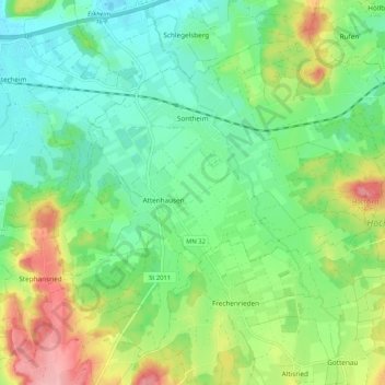
Name: Sontheim topographic map, elevation, terrain.
Location: Sontheim, Landkreis Unterallgäu, Bayern, 87776, Deutschland (47.96611 10.31278 48.02587 10.41760)
Average elevation: 638 m
Minimum elevation: 594 m
Maximum elevation: 724 m
Other topographic maps
Click on a map to view its topography, its elevation and its terrain.
Lachen
Deutschland > Bayern > Landkreis Unterallgäu
Lachen, Memmingerberg, Landkreis Unterallgäu, Bayern, 87760, Deutschland
Average elevation: 653 m