
San Miniato topographic map
Interactive map
Click on the map to display elevation.
About this map
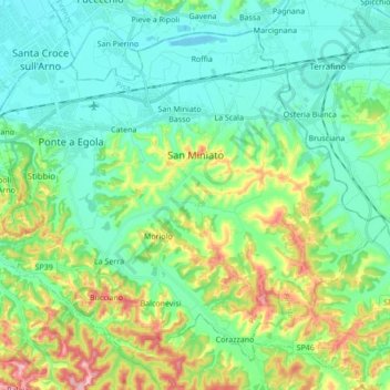
Name: San Miniato topographic map, elevation, terrain.
Location: San Miniato, Pisa, Tuscany, Italy (43.61418 10.76292 43.71939 10.93409)
Average elevation: 69 m
Minimum elevation: 10 m
Maximum elevation: 231 m
San Miniato has a railway station on the Pisa-Florence line. Due to topography the line lies on the flat plain to the north, around 4km from the town centre. A local bus links the station to the hilltop town.
Other topographic maps
Click on a map to view its topography, its elevation and its terrain.
Castelfranco di Sotto
Castelfranco di Sotto, Pisa, Tuscany, Italy
Average elevation: 34 m
Montebicchieri
Italy > Tuscany > Pisa > San Miniato
Montebicchieri, San Miniato, Pisa, Tuscany, 56024, Italy
Average elevation: 79 m
Monteverdi Marittimo
Italy > Tuscany > Pisa > Monteverdi Marittimo
Monteverdi Marittimo, Pisa, Tuscany, Italy
Average elevation: 253 m