Geolocate

Aring topographic map

Click on the map to display elevation.

About this map

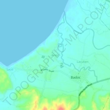
Name: Aring topographic map, elevation, terrain.

Location: Aring, Ilocos Norte, Ilocos Region, 2904, Philippines (17.91476 120.44625 17.95476 120.48625)

Average elevation: 10 m

Minimum elevation: 0 m

Maximum elevation: 59 m

Other topographic maps

Click on a map to view its topography, its elevation and its terrain.

Pagudpud

Philippines > Ilocos Norte

The town's topography includes mountains, hills, valleys and flat coastal land.

Average elevation: 72 m

Saud Beach

Philippines > Ilocos Norte > Pagudpud > Saud

Average elevation: 18 m

Gear up for your next adventure:

👕Technical Hiking Tees - Moisture-management for high-exertion climbs
GPS Outdoor Watches - Watches with GPS tracking for hiking and exploration
❄️Walking Crampons - Added traction for icy slopes and winter peak bagging
🩹Hiking First Aid Kits - Compact medical kits tailored for trail injuries and emergencies
🧤Thermal Touchscreen Gloves - Stay warm while operating your GPS or smartphone camera

As an Amazon Associate, this site earns from qualifying purchases at no extra cost to you.