
Champlas du Col topographic map
Interactive map
Click on the map to display elevation.
About this map
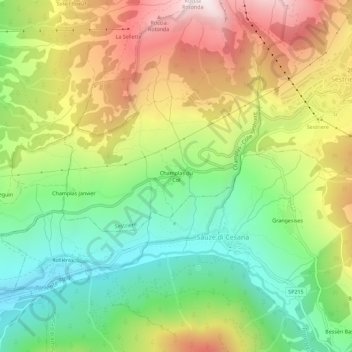
Name: Champlas du Col topographic map, elevation, terrain.
Location: Champlas du Col, Sestrières, Turin, Piémont, 10058, Italie (44.92737 6.83151 44.96737 6.87151)
Average elevation: 1,883 m
Minimum elevation: 1,434 m
Maximum elevation: 2,486 m
Other topographic maps
Click on a map to view its topography, its elevation and its terrain.
Borgata
Italie > Piémont > Turin > Sestrières
Borgata, Sestrières, Turin, Piémont, 10058, Italie
Average elevation: 2,135 m