
Make a donation
Gear up for your next adventure:
As an Amazon Associate, this site earns from qualifying purchases at no extra cost to you.
Paris topographic map
Click on the map to display elevation.
Make a donation
Gear up for your next adventure:
As an Amazon Associate, this site earns from qualifying purchases at no extra cost to you.
Paris
It was first settled near the center of the town in 1779 by Lemuel Jackson, John Willis and their families. Organized as Number Four Plantation, it was incorporated as Paris on June 20, 1793. At the establishment of Oxford County in 1805, Paris was designated its county seat and developed into a thriving community. It was noted for scenic beauty and excellent pasturage, including some of the state's best livestock and dairy farms. It also had many large apple orchards. The village of Paris Hill was established at an elevation of 820 feet (250 m) above sea level, with views of Mount Chocorua and Mount Washington in the White Mountains. The Paris Hill Historic District, added to the National Register of Historic Places in 1973, has fine examples of Federal and Greek Revival architecture. The old Oxford County Jail, built of granite in 1822, was given in 1902 to the Paris Hill Library Association, and is now the Hamlin Memorial Library and Museum.
Make a donation
Gear up for your next adventure:
As an Amazon Associate, this site earns from qualifying purchases at no extra cost to you.
About this map
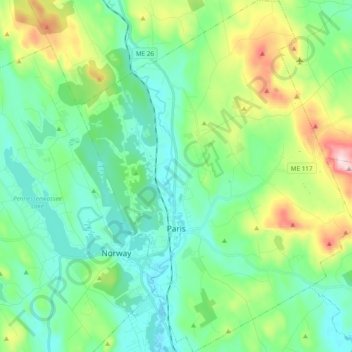
Name: Paris topographic map, elevation, terrain.
Location: Paris, Oxford County, Maine, 04281, United States (44.17542 -70.56621 44.31241 -70.41497)
Average elevation: 207 m
Minimum elevation: 91 m
Maximum elevation: 531 m
Make a donation
Gear up for your next adventure:
As an Amazon Associate, this site earns from qualifying purchases at no extra cost to you.
Other topographic maps
Click on a map to view its topography, its elevation and its terrain.
Mad River Falls
United States > Maine > Oxford County > Batchelders Grant Township
Average elevation: 495 m
Sturtevant Pond
United States > Maine > Oxford County > Magalloway Plantation
Average elevation: 406 m
Make a donation
Gear up for your next adventure:
As an Amazon Associate, this site earns from qualifying purchases at no extra cost to you.