
Moers topographic map
Interactive map
Click on the map to display elevation.
About this map
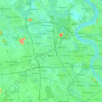
Name: Moers topographic map, elevation, terrain.
Location: Moers, Kreis Wesel, North Rhine-Westphalia, Germany (51.39080 6.55837 51.52378 6.67874)
Average elevation: 28 m
Minimum elevation: 11 m
Maximum elevation: 98 m
Other topographic maps
Click on a map to view its topography, its elevation and its terrain.
Schermbeck
Germany > North Rhine-Westphalia > Kreis Wesel
Schermbeck, Kreis Wesel, North Rhine-Westphalia, 46514, Germany
Average elevation: 47 m
Voerde (Niederrhein)
Germany > North Rhine-Westphalia > Kreis Wesel
Voerde (Niederrhein), Kreis Wesel, North Rhine-Westphalia, 46562, Germany
Average elevation: 27 m
Labbeck
Germany > North Rhine-Westphalia > Kreis Wesel
Labbeck, Sonsbeck, Kreis Wesel, North Rhine-Westphalia, 47665, Germany
Average elevation: 43 m
Sonsbeck
Germany > North Rhine-Westphalia > Kreis Wesel
Sonsbeck, Kreis Wesel, North Rhine-Westphalia, 47665, Germany
Average elevation: 31 m
Wesel
Germany > North Rhine-Westphalia > Kreis Wesel
Wesel, Kreis Wesel, North Rhine-Westphalia, Germany
Average elevation: 26 m