
Pic de la Munia topographic map
Interactive map
Click on the map to display elevation.
About this map
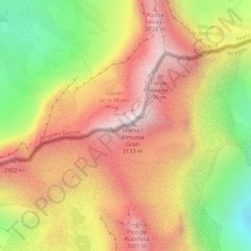
Name: Pic de la Munia topographic map, elevation, terrain.
Location: Pic de la Munia, Bielsa, Sobrarbe, Huesca, Aragón, Spanje (42.71465 0.13090 42.71475 0.13100)
Average elevation: 2,560 m
Minimum elevation: 1,869 m
Maximum elevation: 3,115 m
Other topographic maps
Click on a map to view its topography, its elevation and its terrain.
Monte Perdido
Monte Perdido, Bielsa, Sobrarbe, Huesca, Aragón, Spanje
Average elevation: 2,807 m