
La Colmena topographic map
Interactive map
Click on the map to display elevation.
La Colmena
It is at the northern foot of the Cerro Apitagua, a 25-mile east–west ridge formed by volcanic activity. The steep ascent reaches an altitude of 2,000 feet above sea level in some places. La Colmena is located along the relatively gentle slopes that are between 100 and 400 feet above sea level.
About this map
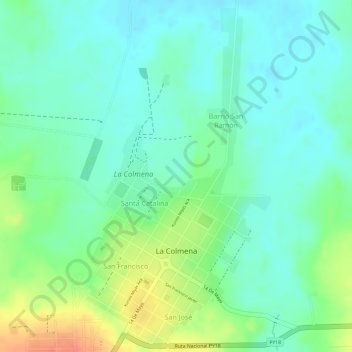
Name: La Colmena topographic map, elevation, terrain.
Average elevation: 157 m
Minimum elevation: 138 m
Maximum elevation: 193 m
Other topographic maps
Click on a map to view its topography, its elevation and its terrain.
Night With. Haunted Forests
Paraguay > Department of Paraguari > Escobar District
Average elevation: 289 m