
Thank you for supporting this site ❤️
Make a donation
Make a donation
Gear up for your next adventure:
As an Amazon Associate, this site earns from qualifying purchases at no extra cost to you.
Stabbia topographic map
Click on the map to display elevation.
Thank you for supporting this site ❤️
Make a donation
Make a donation
Gear up for your next adventure:
As an Amazon Associate, this site earns from qualifying purchases at no extra cost to you.
About this map
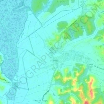
Name: Stabbia topographic map, elevation, terrain.
Location: Stabbia, Cerreto Guidi, Firenze, Toscana, Italia (43.76521 10.81107 43.80521 10.85107)
Average elevation: 23 m
Minimum elevation: 9 m
Maximum elevation: 84 m
Thank you for supporting this site ❤️
Make a donation
Make a donation
Gear up for your next adventure:
As an Amazon Associate, this site earns from qualifying purchases at no extra cost to you.