
Juns topographic map
Interactive map
Click on the map to display elevation.
About this map
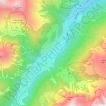
Name: Juns topographic map, elevation, terrain.
Location: Juns, Tux, Bezirk Schwaz, 6192, Österreich (47.11941 11.69275 47.15941 11.73275)
Average elevation: 1,752 m
Minimum elevation: 1,257 m
Maximum elevation: 2,454 m
Other topographic maps
Click on a map to view its topography, its elevation and its terrain.
Zillertal
Österreich > Bezirk Schwaz > Kaltenbach
Zillertal, Kaltenbach, Bezirk Schwaz, Österreich
Average elevation: 1,499 m
Großer Ahornboden
Österreich > Bezirk Schwaz > Vomp
Großer Ahornboden, Vomp, Bezirk Schwaz, 6215, Österreich
Average elevation: 1,523 m
Pfeiler
Österreich > Bezirk Schwaz > Gerlosberg
Pfeiler, Gerlosberg, Bezirk Schwaz, 6281, Österreich
Average elevation: 2,137 m
Eben am Achensee
Eben am Achensee, Bezirk Schwaz, Österreich
Average elevation: 1,401 m
Ried im Zillertal
Ried im Zillertal, Bezirk Schwaz, 6273, Österreich
Average elevation: 1,038 m
Kleinschwendberg
Österreich > Bezirk Schwaz > Burgstall
Kleinschwendberg, Burgstall, Schwendau, Bezirk Schwaz, 6283, Österreich
Average elevation: 1,041 m
Ried
Österreich > Bezirk Schwaz > Gerlos
Ried, Gerlos, Bezirk Schwaz, 6281, Österreich
Average elevation: 1,567 m
Neu-Terfens
Österreich > Bezirk Schwaz > Terfens
Neu-Terfens, Terfens, Bezirk Schwaz, 6123, Österreich
Average elevation: 688 m
Schneekopf
Österreich > Bezirk Schwaz > Vomp
Schneekopf, Vomp, Bezirk Schwaz, 6123, Österreich
Average elevation: 1,722 m
Zemmgrund
Österreich > Bezirk Schwaz > Mayrhofen
Zemmgrund, Mayrhofen, Bezirk Schwaz, Österreich
Average elevation: 2,045 m
Plattenspitze
Österreich > Bezirk Schwaz > Vomp
Plattenspitze, Vomp, Bezirk Schwaz, Österreich
Average elevation: 2,000 m
Hochstall
Österreich > Bezirk Schwaz > Finkenberg
Hochstall, Finkenberg, Bezirk Schwaz, Österreich
Average elevation: 2,332 m
Aschau im Zillertal
Aschau im Zillertal, Bezirk Schwaz, 6274, Österreich
Average elevation: 1,251 m
Zellberg
Zellberg, Bezirk Schwaz, 6277, Österreich
Average elevation: 1,352 m
Ginzling
Österreich > Bezirk Schwaz > Mayrhofen
Ginzling, Mayrhofen, Bezirk Schwaz, 6295, Österreich
Average elevation: 1,564 m
Gemeinde Hippach
Gemeinde Hippach, Bezirk Schwaz, Tirol, 6283, Österreich
Average elevation: 1,745 m