Geolocate

Majdal topographic map

Interactive map

Click on the map to display elevation.

About this map

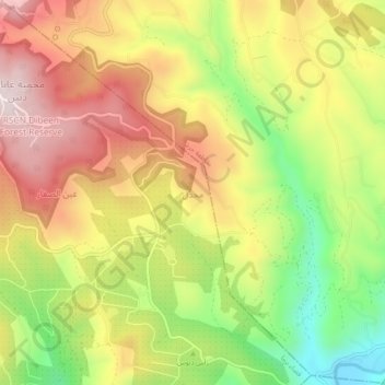
Name: Majdal topographic map, elevation, terrain.

Location: Majdal, Borma Sub-District, Qasabah Jerash, Jarash, Jordan (32.21333 35.83000 32.25333 35.87000)

Average elevation: 487 m

Minimum elevation: 208 m

Maximum elevation: 740 m

Other topographic maps

Click on a map to view its topography, its elevation and its terrain.

RSCN Dibeen Forest Reserve

Jordan > Jarash > Borma Sub-District

RSCN Dibeen Forest Reserve, Borma Sub-District, Qasabah Jerash, Jarash, 26710, Jordan

Average elevation: 644 m

Husainyyat

Jordan > Jarash > Borma Sub-District

Husainyyat, Borma Sub-District, Qasabah Jerash, Jarash, 26710, Jordan

Average elevation: 965 m

King Talal Dam

Jordan > Jarash > Borma Sub-District

King Talal Dam, Borma Sub-District, Qasabah Jerash, Jarash, Jordan

Average elevation: 269 m